Willard Historical Images
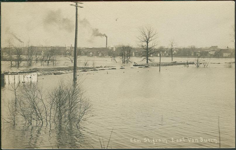
East Van Buren and Elm Streets in flood of 1908
JavaScript is disabled for your browser. Some features of this site may not work without it.
| dc.coverage.temporal | Battle Creek. Michigan, circa 1908 | en_US |
| dc.identifier.other | LPC-033-014-001 | en_US |
| dc.identifier.uri | http://dspace.willardlibrary.org/xmlui/handle/123456789/12805 | |
| dc.description | Postcard showing a photo of Elm Street and East Van Buren Street during the flood of 1908. Battle Creek experienced major flooding in the downtown area in 1887, 1896, 1904, 1908, 1912, 1918, and 1947. By the mid-1950's local leaders worked with the federal government to vacate properties in the flood-prone neighborhood southwest of downtown Battle Creek known as "the bottoms." By 1954 a coalition of local industries and foundations and the federal government was formed to clear housing in the Bottoms. Displaced residents were encouraged to move to the Washington Heights neighborhood. Work began with the Army Core of Engineers on the "Cement River Project" to straighten the Kalamazoo River and channel it so that it no longer could flood the downtown area or displace homeowners. Caption on front: Elm St. from East Van Buren Caption on back: Flood Battle Creek, Mich March 1908 | en_US |
| dc.format.medium | b&w postcard | en_US |
| dc.language.iso | En | en_US |
| dc.subject | Floods | en_US |
| dc.subject | Floods, Cyclones | en_US |
| dc.title | East Van Buren and Elm Streets in flood of 1908 | en_US |
| dc.type | Image | en_US |